
How LiDAR Mapping Works in Robot Vacuums (Tech Explained): From Laser Scans to Smart Cleaning Paths
Aaron Cooper1. Introduction: Why LiDAR Mapping Is the Brain Behind Smart Robot Vacuums
Ever watched a cheap robot vacuum ping-pong across your living room like it’s lost? Yeah—that’s the difference between “cleaning” and actually knowing what you’re doing.
LiDAR mapping is what turns a robot vacuum from a clumsy bumper car into something that feels… almost intentional. It’s the brain behind those clean, straight lines, the reason it remembers your rooms, and why it doesn’t keep re-cleaning the same dusty corner.
At its core, LiDAR (Light Detection and Ranging) uses laser pulses to scan your home, feeding that data into SLAM—basically the robot’s internal GPS + memory system. Together, they build a live map, track position, and plan efficient paths.
In this guide, we’ll break down exactly how that happens—from laser measurements to smart navigation—and, more importantly, what it means for your everyday cleaning experience.
2. How LiDAR Actually Measures Your Home: Time-of-Flight, LDS, and dToF Explained

2.1 Laser Distance Measurement: The Time-of-Flight Principle
Let’s start with the magic trick: how does a tiny robot figure out the size of your living room without touching anything?
It’s all about timing. Literally.
A LiDAR-equipped robot vacuum constantly fires invisible laser pulses in every direction. When those pulses hit your walls, furniture, or even chair legs, they bounce back. The robot measures exactly how long that round trip takes. Since the speed of light is constant, it can calculate distance with surprising precision.
Here’s where it gets impressive: these measurements happen so fast and so frequently that the robot builds a real-time snapshot of its surroundings while moving. You don’t see the math—but you feel it when your vacuum glides neatly along edges instead of crashing into them.
And that’s the foundation of everything. No guessing. No randomness. Just physics doing the heavy lifting.
2.2 LDS vs dToF: Two Ways Robot Vacuums ‘See’ Distance
Now, not all LiDAR systems are built the same. If you’ve ever noticed some robots with that little spinning “puck” on top—and others without—it comes down to two main technologies: LDS and dToF.
LDS (Laser Distance Sensor)
- Uses a rotating turret that spins 360°, scanning the entire room.
- Relies on triangulation using angles and reflections to estimate distance.
- Widely used, reliable, and gives full-room coverage in a single sweep.
dToF (direct Time-of-Flight)
- Measures the exact time each laser pulse travels rather than geometry.
- Often built into the body (no turret), allowing for slimmer designs.
- Typically faster and more precise in capturing depth data.
According to industry comparisons of LDS vs dToF LiDAR systems, LDS remains the more common and cost-effective solution, while dToF is increasingly used in premium models for its compact design and direct measurement accuracy.
So which is better? It depends.
- Want proven, full 360° scanning? LDS delivers.
- Want a lower-profile robot that slips under more furniture? dToF has the edge.
Either way, both are doing the same core job: constantly measuring distance, feeding data into the robot’s brain, and making sure your vacuum doesn’t clean like it’s guessing.
3. From Laser Points to a Usable Map: SLAM, Point Clouds, and Occupancy Grids
3.1 Turning Raw Laser Data into a 2D Map
So now your robot has thousands of distance readings every second. Great—but raw numbers don’t clean floors.
Here’s where things get interesting.
Each laser measurement has two key pieces of information:
- The angle it was fired at
- The distance it traveled
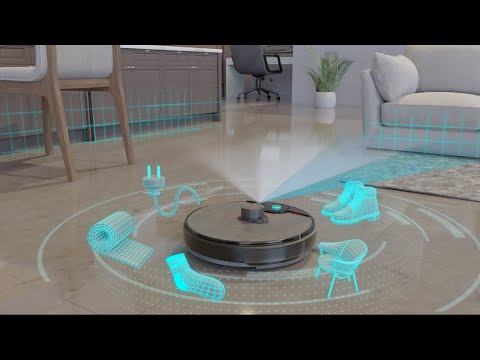
Using basic math (the kind you probably hoped you’d never use again), the robot converts those polar coordinates into X-Y points—actual positions on a map. Do this fast enough, and suddenly you have a “point cloud”: a rough sketch of your room made entirely of dots.
At first, it’s messy. Just scattered points representing walls, furniture edges, and obstacles. But as more scans pile up, patterns emerge. Straight lines become walls. Clusters become furniture. Open areas become navigable floor.
It’s like watching a puzzle assemble itself in real time.
And this is why your robot doesn’t just wander aimlessly. It’s not guessing where the couch is—it knows, because it’s already mapped the outline using thousands of tiny laser measurements stitched together.
3.2 What SLAM Really Does: Mapping While Tracking Position
Now comes the real brainpower: SLAM.
SLAM stands for Simultaneous Localization and Mapping—which sounds complicated, but the idea is simple:
Your robot is building a map while figuring out where it is inside that map.
Here’s how it works in practice:
- LiDAR provides distance data (what’s around me?)
- Wheel encoders track movement (how far did I go?)
- Sometimes an IMU tracks orientation (did I turn?)
All of this gets fused together so the robot can constantly update its “pose”—its exact position and direction—inside the evolving map. It continuously compares new scans with previous ones, correcting errors along the way. That’s why your map doesn’t end up warped after a long cleaning run.
The result? A robot that knows where it started, where it’s been, and exactly where it still needs to go. No overlap. No missed zones. Just clean logic.
3.3 Occupancy Grids: How Robots Decide What’s Floor vs Obstacle
So how does your robot turn that abstract map into actual cleaning decisions?
Enter the occupancy grid—the behind-the-scenes system that decides what’s cleanable space and what’s not.
Picture your home divided into thousands of tiny squares. Each square gets labeled as one of three things:
- Free: go ahead, clean here
- Occupied: wall, furniture, obstacle
- Unknown: haven’t scanned this yet
As the robot moves and scans, it keeps updating these squares. A laser beam that hits something? That cell becomes “occupied.” A beam that passes through empty space? That path becomes “free.”
Over time, this grid transforms into a highly reliable floor plan. This is what allows your robot to clean in those satisfying, straight lines instead of chaotic zig-zags. It’s not just moving—it’s making decisions based on a constantly updated model of your home.
And once that clicks, you realize: it’s not just cleaning. It’s navigating with intent.
4. Step-by-Step: What Happens During a Real Cleaning Run

4.1 First Mapping Run: How Your Robot Builds the Initial Floor Plan
That very first run? It’s not really cleaning—it’s your robot learning your home from scratch.
You hit “start,” and instead of rushing around sucking up dust, the robot moves more deliberately. It hugs walls, pauses, rotates, scans. Every movement is feeding data into its LiDAR + SLAM system.
That’s why most setup guides emphasize:
- Open all doors you want included
- Clear small objects like cables and toys
- Start from the dock and don’t move the robot mid-run
As it explores, it detects walls as continuous lines and furniture as clusters, gradually forming a usable floor plan. By the end of the run, that messy cloud of laser points becomes something recognizable: rooms, boundaries, pathways.
Then it docks. And saves everything.
From that moment on, your robot isn’t guessing anymore—it’s working from a blueprint of your home.
4.2 Real-Time Updates: How the Map Evolves While Cleaning
Here’s the part most people don’t realize: the map is never “done.”
Every single movement triggers a loop:
scan → compare → adjust → update.
As the robot moves, it constantly compares new LiDAR scans to the existing map. If something doesn’t line up—maybe you moved a chair or left a laundry basket out—it updates the local map and reroutes in real time.
This is where SLAM quietly does its best work.
The result?
A map that gets smarter as it cleans. Not worse.
So instead of that old-school frustration—robots getting lost, spinning in circles, or missing half the room—you get something that adapts on the fly and stays on track.
4.3 What You See in the App vs What the Robot Actually Computes
Let’s be honest—the app makes everything look simple. A clean floor plan, a little robot icon, maybe some neat zig-zag lines. But under the hood? It’s doing way more than that.
What you see
- A map with rooms and walls
- A moving robot icon
- Cleaned areas highlighted
- Buttons for “Kitchen only” or “No-go zone here”
What the robot actually uses
- A dense occupancy grid (thousands of tiny cells)
- Continuous pose estimation (exact position + angle)
- Real-time path planning across that grid
That little robot icon? It’s not just moving randomly—it’s the live output of SLAM calculating its position multiple times per second.
Those straight cleaning lines? They come from coverage algorithms designed to systematically hit every reachable “free” cell without overlap.
And those no-go zones you draw? They literally become forbidden regions in the robot’s navigation map.
So when it feels like your robot “understands” your home—it kind of does. Just not in the way you might expect.
5. Why LiDAR Mapping Is Better: Real-World Benefits You’ll Notice
5.1 Faster, More Efficient Cleaning (No More Random Bouncing)
Let’s talk about the real pain: watching a cheap robot vacuum clean the same spot three times… and still miss crumbs right next to it.
That’s what random navigation does. It eventually covers the space—but wastes time, battery, and your patience along the way.
LiDAR changes that completely. Instead of wandering, the robot follows structured, back-and-forth paths—like mowing a lawn. It knows where it’s been, where it’s going, and how to cover every inch without overlap.
Independent comparisons consistently show that LiDAR-based robots clean in straight, logical lines rather than chaotic patterns, which directly translates to faster and more complete coverage.
- Less time running
- Fewer missed spots
- More area covered per charge
5.2 Better Obstacle Avoidance and Coverage Accuracy
You know that moment when a robot slams into a chair leg… backs up… tries again… and just keeps bumping? That’s what happens when a robot only reacts after hitting something.
LiDAR flips that behavior. Because it’s constantly scanning the environment, it detects obstacles before contact. Walls, table legs, furniture edges—they all appear in the map as “occupied” zones, so the robot plans around them instead of crashing into them.
The result feels smoother. Smarter. It glides along edges instead of bouncing off them. It navigates tight spaces with fewer corrections.
5.3 Works in the Dark: A Key Advantage Over Camera-Based Systems
Here’s a simple question: when do you actually want your robot to clean? Probably when you’re not around. Maybe at night. Maybe while you’re at work with the blinds closed.
Now imagine your robot needs the lights on to function properly. That’s the limitation of camera-based systems. LiDAR doesn’t care.
Because it generates its own laser signals, it works just as well in complete darkness as it does in daylight. According to comparisons between LiDAR and camera-based navigation, this independence from ambient light is one of LiDAR’s biggest real-world advantages.
- Schedule cleaning overnight without thinking twice
- Run it while you’re out, even in dim rooms
- No weird “lost robot” moments because the lights were off
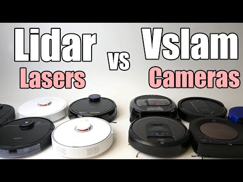
6. LiDAR vs Camera (vSLAM) vs Hybrid Systems: Which One Should You Choose?
6.1 LiDAR vs vSLAM: Key Differences in Accuracy, Speed, and Reliability
At a glance, both systems “map your home.” But how they see the world couldn’t be more different.
- LiDAR measures distance using lasers
- vSLAM uses cameras to interpret visual features like edges and textures
| Aspect | LiDAR | vSLAM (Camera) |
|---|---|---|
| Mapping accuracy | Highly precise geometry | Depends on visual features |
| Speed | Fast map creation, efficient routes | Often slower to stabilize |
| Lighting | Works in total darkness | Needs good lighting |
| Reliability | Consistent across environments | Can struggle with low light |
6.2 Hybrid Systems: Combining Laser Precision with Camera Intelligence
So what if you could get the best of both? That’s exactly what hybrid systems aim to do. They use LiDAR for precise mapping and navigation and Cameras for object recognition.
Why does that matter? Because LiDAR knows where something is—but not what it is. A cable, a sock, or… something you really don’t want smeared across your floor? To LiDAR, they can look similar.
That’s why modern hybrid robots can:
- Recognize and avoid cables instead of eating them
- Detect small objects LiDAR might miss
- Adapt better in cluttered homes
6.3 Which Navigation Tech Fits Your Home Best?
It comes down to how your home behaves day-to-day.
- Go with LiDAR if: You want reliable, hands-off cleaning; your home has multiple rooms; or you plan to run it in low light.
- Consider vSLAM if: You need a lower-profile robot (no LiDAR turret); your home is small and well-lit; or budget is a bigger concern.
- Choose Hybrid if: Your floors are often cluttered (cables, toys, pet stuff); you want the smartest possible obstacle avoidance.
If your goal is simple—set it and forget it—LiDAR (or hybrid) is usually the safest bet.
7. Conclusion: From Laser Pulses to Spotless Floors
What looks like a simple cleaning gadget is actually doing something pretty incredible. Every second, your robot vacuum is firing laser pulses, calculating distances, updating a map, and deciding the most efficient path forward—all while quietly cleaning your floors.
That’s the real power of LiDAR.
It transforms robot vacuums from random, bumping machines into systems that understand your home, adapt to changes, and clean with purpose. The result isn’t just better coverage—it’s less time wasted, fewer frustrations, and a level of consistency that older navigation methods simply can’t match.
If you care about efficiency, reliability, and truly hands-off cleaning, LiDAR isn’t just a nice feature. It’s the foundation that makes everything else work.
FAQ
Q: What is the main benefit of LiDAR in a robot vacuum?
A: LiDAR allows the robot to build precise 2D maps and navigate in straight, efficient lines rather than random patterns. It significantly reduces cleaning time and ensures full room coverage by tracking exactly where the vacuum has already cleaned and where it needs to go next.
Q: Does LiDAR mapping work in complete darkness?
A: Yes. Unlike camera-based vSLAM systems that require ambient light to recognize visual features, LiDAR uses its own laser pulses to measure distance. This makes it highly effective for scheduled nighttime cleaning or working in dim rooms without any loss in navigation accuracy.
Q: What is the difference between LDS and dToF LiDAR?
A: LDS (Laser Distance Sensor) typically features a rotating turret for 360-degree scanning and is widely proven. dToF (direct Time-of-Flight) is a newer technology that measures the exact travel time of light, often offering higher precision, faster scanning, and a more compact, low-profile design.
Q: Can LiDAR-based robots avoid small obstacles like cables?
A: While LiDAR is excellent at detecting walls and furniture, very low or thin objects like power cables can sometimes be missed because they sit below the laser's scanning plane. Many premium models now use hybrid systems with cameras to improve detection of these small items.
Q: Why does the robot need a mapping run first?
A: The initial mapping run allows the LiDAR system to establish a baseline blueprint of your home. By exploring boundaries and identifying permanent structures, the robot creates a saved occupancy grid that it uses to plan systematic cleaning paths for all future sessions.